
![]()
A walking tour of the village
![]()
![]()
![]()
![]()
![]()
![]()
|
|
|
|
A walking tour of the village |
|
|
|
|
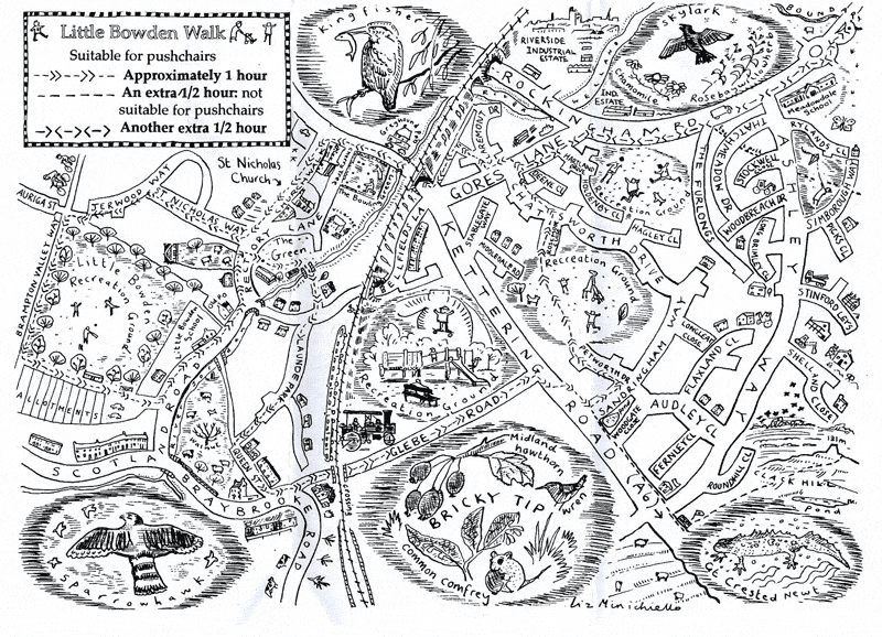
The tour starts on the Green to the south of the parish church of St Nicholas.
The Green was given to
the parish in 1961 by Nellie Bird for use as a public open space. Cross the
Green to the scout hut and you come to the Jordan Brook, a tributary of
the River Welland. Until the early 1920s, the
brook ran around the outside of the Green,
along the course of Rectory Lane, but was diverted to its present course as part
of an early flood prevention scheme. Crossing the brook on a footbridge, you
walk along a delightful hedged path to Honey Bank House and the Scotland Road.
Turn right and then left into Launde Park, which was formerly allotments.
Follow the road and footpath south to Queen Street, a quiet, cul-de-sac which in
fact continues west with a footpath linking it with Scotland Road.
This route was originally known as Middle Row. To the south is a small field
still grazed by sheep formerly known as Dovecote Close. A rare survival of
agricultural land in the heart of a historic village - something that has
changed little from medieval times. Look out for a beautiful walnut tree in the
middle of the field. Turn left and walk along Queen Street and then turn left
again into Braybrooke Road.
Walk
straight ahead, crossing the Midland Mainline railway into Glebe Road, a
path that was once the original main north road on the east side of the village.
The building of the railway in 1857 cut off this route to all but walkers.
Originally it ran up to and across Kettering Road and into the
former East Field of the
village.Here it was known as the Stable/ Staple Gateway. Immediately after the
crossing you find the Welland Valley Vintage Traction Club..
Half way along Glebe Road on the left is the recreation ground created
out of the site of the Little Bowden Brick Works. Between the 1790s and 1920s
the kilns here turned locally-dug clay into building material. Until the late
1930s a large clay pit ("Bricky Tip") lay on the other side of Glebe Road from
the brick works. The area still retains its name and is a valuable wildlife
habitat. Look out for small woodland birds and mammals living off and amongst
the varied plant life: common comfrey, blackthorn, midland hawthorn, dog rose
and teasels. Small mammals use tussocks of tufted fescue grass for nesting.
Follow Glebe Road north to Kettering Road where it starts to climb Clack Hill and cross into Sandringham Way. Turn left into Petworth Drive to reach one of the Rockingham Road/ Kettering Road developments' three Recreation Grounds. Cross to continue through the estate along Rosemoor Close, left onto Chatsworth Drive, right onto Gores Lane and the Rockingham Road and on towards the roundabout on the A6 bypass. To your left is the former meadow of Little Bowden with the River Welland winding along its edge, until 1888 the border between Leicestershire and Northamptonshire.
At the lay-by before the A6 junction a stream runs down from the high ground on the right, flows under the Rockingham Road and joins the Welland on the left. This stream forms the northern boundary of the historic parish of Little Bowden.
Turn back along the Rockingham Road passing the Welland Industrial Estate on your right. Turn left into Gores Lane named after an irregular field that used to occupy all the land on the right hand side (a "Gore").
Half way along Gores Lane turn right into Claremont Drive walking towards the railway embankment until you find a footpath. Turn left onto it and you will emerge by the bridge over the Kettering Road.
Turn right onto Kettering Road, pausing on the River Jordan bridge to look for Kingfishers and Moorhens. On the west side of the railway embankment is the Bowling Green, opened in 191.2.
Cross Rectory Lane to reach Church Walk, a passageway alongside the Cherry Tree pub (at least 200 years old).
The small parish church of St Nicholas has been here for at least 800 years and the churchyard contains many interesting and finely carved headstones, some dating from the 1760's, as well as several mature trees. One of the few neighbourhood oaks stands beside the gate.
Come out of the churchyard onto The Green and turn right into St Nicholas Way. Follow the road into Jerwood Way which leads into the Little Bowden Recreation Ground (created in 1905) with its fine avenue of horse chestnut trees and alternating chestnuts and limes planted around the -perimeter of the cricket field.
To the right the path through the Recreation Ground runs into Auriga Street and onto Northampton Road after crossing the course of the former Harborough to Northampton railway line, which was built in 1859 and closed to passengers in 1960. Until 1990 there was a small foot tunnel under the line to Auriga Street. The course of the railway is now used as the Brampton Valley Way for walkers and cyclists.
Cross the Recreation Ground to the allotments created to provide the poor with means of growing their own food and still popular today.
Turn left onto a path at the side of the allotments which runs into the Scotland Road car park. This road takes its name from the type of land tenure practised in this part of the village, nothing to do with the Scottish nation Turn left into Scotland Road and then return to the village green, passing on the left the fine Little Bowden School, built in 1907 to the designs of two important local architects, H G Coales and H W Johnson.
Beyond, at the junction with Rectory Lane is an attractive thatched cottage, which in parts is at least 250 years old and used to house the village post office.
Turn into Rectory Lane and before finishing the tour look left to admire another small close of land tucked between houses and still used to graze sheep.